


Polygons
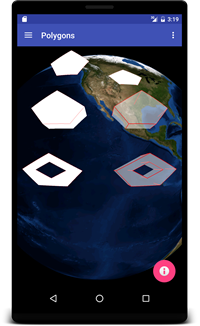
This example renders six different five-sided polygons on the globe.
- The top-left polygon is above ground, using the default ABSOLUTE altitude mode and default attributes.
- The top-right polygon is on the terrain surface, using a CLAMP_TO_GROUND altitude mode and setFollowTerrain(true).
- The middle-left polygon is above ground, like the top-left, but with setExtrude(true).
- The middle-right polygon is like the middle-left, but with custom attributes.
- The bottom-left polygon contains an inner ring specified with addBoundary(List).
- The bottom-right polygon is like the bottom-left, but with setExtrude(true) and custom attributes.
PolygonsFragment.java
The PolygonsFragment class extends the BasicGlobeFragment and overrides the createWorldWindow method. Here we create and add a RenderableLayer to the globe, and then define and add four Polygons to the layer.
package gov.nasa.worldwindx;
...
public class PolygonsFragment extends BasicGlobeFragment {

    /**
     * Creates a new WorldWindow (GLSurfaceView) object with a set of Polygon shapes
     *
     * @return The WorldWindow object containing the globe.
     */
    @Override
    public WorldWindow createWorldWindow() {
        // Let the super class (BasicGlobeFragment) do the creation
        WorldWindow wwd = super.createWorldWindow();

        // Create a layer to display the tutorial polygons.
        RenderableLayer layer = new RenderableLayer();
        wwd.getLayers().addLayer(layer);

        // Create a basic polygon with the default attributes, the default altitude mode (ABSOLUTE),
        // and the default path type (GREAT_CIRCLE).
        List<Position> positions = Arrays.asList(
        Position.fromDegrees(40, -135, 5.0e5),
        Position.fromDegrees(45, -140, 7.0e5),
        Position.fromDegrees(50, -130, 9.0e5),
        Position.fromDegrees(45, -120, 7.0e5),
        Position.fromDegrees(40, -125, 5.0e5)
        );
        Polygon poly = new Polygon(positions);
        layer.addRenderable(poly);

        // Create a terrain following polygon with the default attributes, and the default path type (GREAT_CIRCLE).
        positions = Arrays.asList(
        Position.fromDegrees(40, -105, 0),
        Position.fromDegrees(45, -110, 0),
        Position.fromDegrees(50, -100, 0),
        Position.fromDegrees(45, -90, 0),
        Position.fromDegrees(40, -95, 0)
        );
        poly = new Polygon(positions);
        poly.setAltitudeMode(WorldWind.CLAMP_TO_GROUND); // clamp the polygon vertices to the ground
        poly.setFollowTerrain(true); // follow the ground between polygon vertices
        layer.addRenderable(poly);

        // Create an extruded polygon with the default attributes, the default altitude mode (ABSOLUTE),
        // and the default path type (GREAT_CIRCLE).
        positions = Arrays.asList(
        Position.fromDegrees(20, -135, 5.0e5),
        Position.fromDegrees(25, -140, 7.0e5),
        Position.fromDegrees(30, -130, 9.0e5),
        Position.fromDegrees(25, -120, 7.0e5),
        Position.fromDegrees(20, -125, 5.0e5)
        );
        poly = new Polygon(positions);
        poly.setExtrude(true); // extrude the polygon from the ground to each polygon position's altitude
        layer.addRenderable(poly);

        // Create an extruded polygon with custom attributes that display the extruded vertical lines,
        // make the extruded interior 50% transparent, and increase the polygon line with.
        positions = Arrays.asList(
        Position.fromDegrees(20, -105, 5.0e5),
        Position.fromDegrees(25, -110, 7.0e5),
        Position.fromDegrees(30, -100, 9.0e5),
        Position.fromDegrees(25, -90, 7.0e5),
        Position.fromDegrees(20, -95, 5.0e5)
        );
        ShapeAttributes attrs = new ShapeAttributes();
        attrs.setDrawVerticals(true); // display the extruded verticals
        attrs.setInteriorColor(new Color(1, 1, 1, 0.5f)); // 50% transparent white
        attrs.setOutlineWidth(3);
        poly = new Polygon(positions, attrs);
        poly.setExtrude(true); // extrude the polygon from the ground to each polygon position's altitude
        layer.addRenderable(poly);

        // Create a polygon with an inner ring by specifying multiple overlapping polygon boundaries.
        poly = new Polygon();
        poly.addBoundary(Arrays.asList(
        Position.fromDegrees(0, -135, 5.0e5),
        Position.fromDegrees(5, -140, 7.0e5),
        Position.fromDegrees(10, -130, 9.0e5),
        Position.fromDegrees(5, -120, 7.0e5),
        Position.fromDegrees(0, -125, 5.0e5)
        ));
        poly.addBoundary(Arrays.asList(
        Position.fromDegrees(2.5, -130, 6.0e5),
        Position.fromDegrees(5.0, -135, 7.0e5),
        Position.fromDegrees(7.5, -130, 8.0e5),
        Position.fromDegrees(5.0, -125, 7.0e5)
        ));
        layer.addRenderable(poly);

        // Create an extruded polygon with an inner ring and custom attributes that display the extruded vertical lines,
        // make the extruded interior 50% transparent, and increase the polygon line width.
        poly = new Polygon(attrs);
        poly.addBoundary(Arrays.asList(
        Position.fromDegrees(0, -105, 5.0e5),
        Position.fromDegrees(5, -110, 7.0e5),
        Position.fromDegrees(10, -100, 9.0e5),
        Position.fromDegrees(5, -90, 7.0e5),
        Position.fromDegrees(0, -95, 5.0e5)
        ));
        poly.addBoundary(Arrays.asList(
        Position.fromDegrees(2.5, -100, 6.0e5),
        Position.fromDegrees(5.0, -105, 7.0e5),
        Position.fromDegrees(7.5, -100, 8.0e5),
        Position.fromDegrees(5.0, -95, 7.0e5)
        ));
        poly.setExtrude(true); // extrude the polygon from the ground to each polygon position's altitude
        layer.addRenderable(poly);

        return wwd;
    }
}